Google Earth Cache Manager is a program that handle the cache of the Google Earth (dbCache.dat) and produce a satellite images (in BMP format) from cache extractions. (cache extractor using JPG Extractor from Eugeny Vedernicov -- enved[at]mail.ru --).
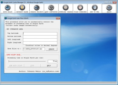
The first process is collects the cache in online mode with Google Earth (GE), with some value of eye altitude (ex: 3000 feet = zoom 19 quality image), and let the GE finish the streaming, in the other hand, GE cache is more increasing in number of tiles (256x256 pixel images) database. The more we get the cache in online mode, more wide area we can create the satellite images.
The GECM calculate the number of tiles to be used, within the input of latitude, longitude, and zoom factor by user. Further more, GECM generate the tile coordinate in mercator XY, and create a relational function from QRST code to mercator XY code, with that function, GECM can convert the QRST tile name from extraction to mercator XY name. The XY information then used to combine all tiles into one big BMP image format.
GECM can work with a large tile, (ex: work with ±12000 tiles in 19 zoom quality image can produce aproximately 1,3 GB BMP image format ±100000 hectares area of satellite images). Adobe Photoshop CS3 or equivalent software able to open this large size BMP format. Once it open in Photoshop, convert into TIFF format then create a GEOTIFF with ArcGIS. Now you get the georeferenced satellite image!
Test the GECM Trial version, which is limited in zoom 16 quality image project.
Comments